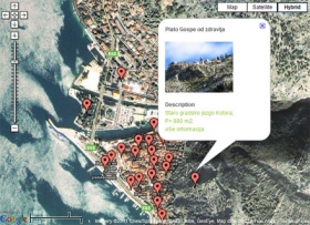
 Expeditio has been implementing the project Sostenuto for two years now, through the MED programme of the EU, with the partners from France, Italy, Slovenia and Spain. This is a big project which involves different activities in the area of culture, with a particular focus on the relation between the culture and social and economic aspects of development. In Montenegro, Expeditio, among others, cooperates with the municipalities of Kotor, Tivat and Herceg Novi on the preparation of local 2011-2015 programmes for the development of culture. One of the activities of this process is the mapping of public spaces which could be better used i.e. become the spaces of public interest. Mapping is concurrently carried out in the municipalities of Kotor, Tivat and Herceg Novi. About 170 locations have been mapped so far.
Mapping of public spaces is carried out according to their use, accessibility, physical characteristics, informatics and equipment of the space. This process started in June and is now in its final phase.
The mapping process involved the identification of public spaces, both those used on a daily basis with the facilities enabling people to stay in them longer and those which have potentials for use but are not utilized or are currently used out of the adequate purpose. Large areas of public spaces in these coastal municipalities are potential spaces for different activities and various social and cultural events, but are unused. Sometimes these spaces are physically unattractive because of neglect and generally bad condition they are in, while sometimes they are poorly equipped– no place for sitting, no greenery, public illumination or they are less accessible. In such condition, these potential centres where citizens and tourists could gather remain unnoticed and unused with their immense beauty and more often than not exposed to human neglect, turned into parking lots, spaces for disposal of unnecessary objects and the like.
Mapping involved the evaluation of actual condition in the field and its verification through the series of questions grouped by categories in order to obtain the field information as accurate as possible, about:
- space area, its occupancy;
- use (social activities, space users);
- accessibility (traffic- motor and pedestrian and for persons with disabilities);
- space development (current condition, greenery, environment, content of the public space);
- equipment of the space
About 170 locations have been mapped in all three municipalities. Soon, through the media, we will invite the citizens to see the locations we recognized and to add some of their own, which they also consider interesting for future activities. Suggestions of the citizens would be important for identification of some other surfaces which might not have been taken into consideration when mapping these spaces, as well as the suggestions relating to their use – manifestations and events in these public spaces and additional possibilities for their use, etc.
The Sostenuto project is co-financed by the European Regional Development Fund and IPA (Instrument for Pre-accession Assistance) through the EU Delegation in Montenegro. A part of funds for these activities were provided through the Programme for Implementation of Local Public Works of the Employment Agency of Montenegro.
More about drawing up of Local Programmes for the development of culture in Boka municipalities at:
http://www.strategija.bokabay.info/


